란도너스 퍼머넌트 PT-216 달서유랑 GPX 코스파일
설명
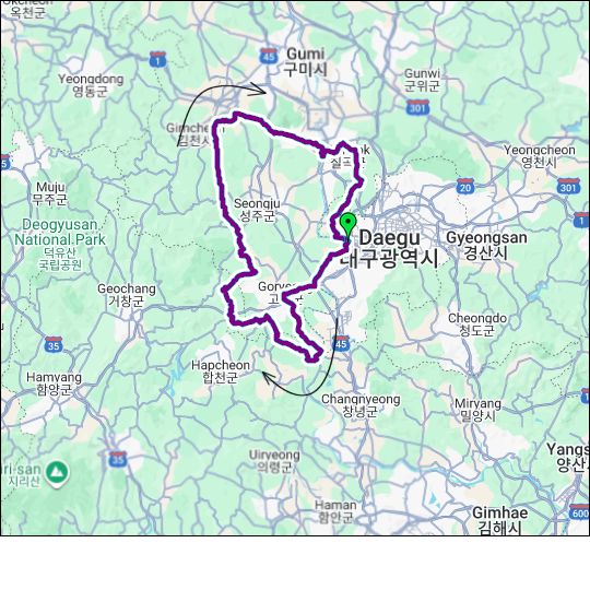 거리: 201 km
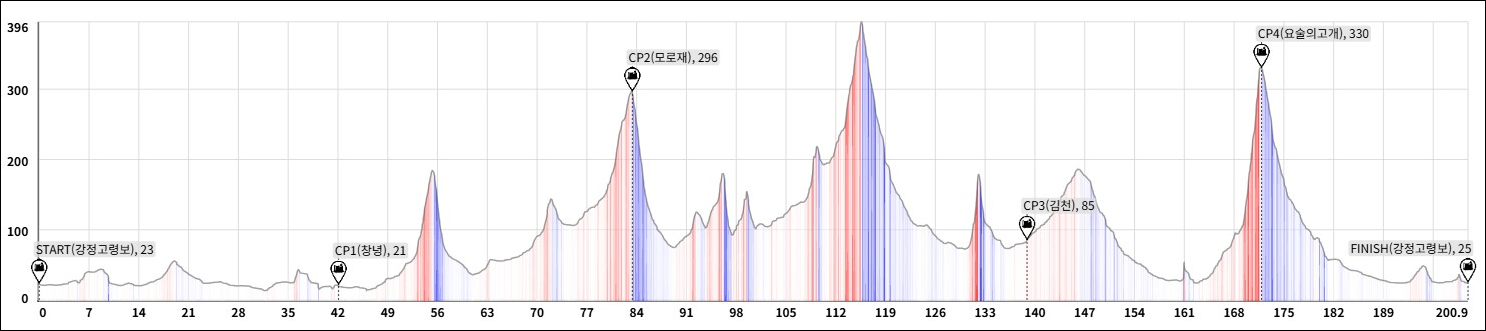
상승고도: 1,650 m
제한시간: 13:24
출발점: 대구
도착점: 대구
코스설계자: 조현호
Last Update : 2026.05.04
https://drive.google.com/drive/folders/1nTzXduyZD5_wvDHMt5rgCJo8FrVYnGTi?usp=drive_link
본 코스는 대구(달구벌)의 서쪽 외곽을 이루는 6개 시·군(고령·창녕·합천·성주·김천·칠곡)을 하나의 커다란 궤적으로 연결하여, 번잡한 도심을 벗어난 내륙 깊숙한 곳의 '진정한 정적'을 만끽할 수 있도록 설계되었습니다. 특히 인위적인 속도 경쟁보다는 풍경과 호흡하며 느리게 흘러가는 유랑의 가치를 코스 전반에 담아냈습니다.
전체 거리 200km 대비 획득고도 약 1,600m라는 순탄한 구성은 라이더에게 체력적 부담 대신 사방으로 펼쳐진 영남 중부 내륙의 평화로운 정취를 선사합니다. 유천령, 모로재, 살티재, 요술의고개 등 주요 언덕들은 도전의 대상이기보다, 고갯마루에서 내려다보는 한적한 마을 풍경을 향유하기 위한 조망점이 됩니다.
달(達) - 달구벌(대구)의 지리적 뿌리이자, 길을 통해 세상과 소통(通達)함
서(西) - 서쪽 내륙의 호젓한 시골길, 해 저무는 노을이 아름다운 방향
유(遊) - 서두르지 않고 즐기며 거니는 여유, 라이딩의 유희적 본질
랑(浪) - 물결치듯 유연하게 이어지는 길 위에서 느끼는 자유로운 방랑
즉, 달서유랑은 "달구벌 서쪽의 고요한 풍경 속을 한가로이 떠도는 여정"을 의미합니다. 이는 단순히 거리를 완주하는 기록의 과정을 넘어, 조용하고 한적한 길을 엄선하여 라이더가 오롯이 풍경의 일부가 되어보는 경험을 지향합니다. 차 소리보다 바람 소리가 앞서는 이 길 위에서, 라이더는 영남 중부 내륙이 간직한 소박한 아름다움을 발견하고 일상의 소음에서 벗어나 '유유자적한 유랑의 기쁨'을 누리게 될 것입니다.
This course connects six counties (Goryeong, Changnyeong, Hapcheon, Seongju, Gimcheon, and Chilgok) forming the western outskirts of Daegu (Dalgubeol) into a single grand trajectory. It is designed to allow riders to fully enjoy the "true serenity" of the deep inland areas, far away from the bustling city center. In particular, rather than an artificial speed competition, the value of "wandering"—flowing slowly while breathing with the scenery—is embedded throughout the course.
The smooth composition of approximately 1,600m elevation gain for a total distance of 200km provides riders with the peaceful atmosphere of the central Yeongnam inland instead of physical strain. Major hills such as Yucheon-ryeong, Moro-jae, Salti-jae, and Josul-gogae are not so much objects of challenge as they are vantage points for enjoying the secluded village scenery from the summits.
Dal (達): The geographical root of Dalgubeol (Daegu), and the act of communicating (通達) with the world through the road.
Seo (西): The secluded country roads of the western inland, the direction where the evening sunset is most beautiful.
Yu (遊): The leisure of strolling without haste, the playful essence of riding.
Rang (浪): A free-spirited wandering felt on the road that flows flexibly like waves.
In other words, Dalseo-Yurang signifies "a journey wandering leisurely through the quiet scenery of western Dalgubeol." Beyond the mere process of recording a completed distance, it aims for an experience where riders become part of the landscape on carefully selected, quiet, and secluded roads.
On this path, where the sound of the wind precedes the sound of cars, riders will discover the simple beauty held by the central Yeongnam inland and enjoy the "joy of leisurely wandering," free from the noise of daily life.
거리: 201 km
상승고도: 1,650 m
제한시간: 13:24
출발점: 대구
도착점: 대구
코스설계자: 조현호
Last Update : 2026.05.04
https://drive.google.com/drive/folders/1nTzXduyZD5_wvDHMt5rgCJo8FrVYnGTi?usp=drive_link
본 코스는 대구(달구벌)의 서쪽 외곽을 이루는 6개 시·군(고령·창녕·합천·성주·김천·칠곡)을 하나의 커다란 궤적으로 연결하여, 번잡한 도심을 벗어난 내륙 깊숙한 곳의 '진정한 정적'을 만끽할 수 있도록 설계되었습니다. 특히 인위적인 속도 경쟁보다는 풍경과 호흡하며 느리게 흘러가는 유랑의 가치를 코스 전반에 담아냈습니다.
전체 거리 200km 대비 획득고도 약 1,600m라는 순탄한 구성은 라이더에게 체력적 부담 대신 사방으로 펼쳐진 영남 중부 내륙의 평화로운 정취를 선사합니다. 유천령, 모로재, 살티재, 요술의고개 등 주요 언덕들은 도전의 대상이기보다, 고갯마루에서 내려다보는 한적한 마을 풍경을 향유하기 위한 조망점이 됩니다.
달(達) - 달구벌(대구)의 지리적 뿌리이자, 길을 통해 세상과 소통(通達)함
서(西) - 서쪽 내륙의 호젓한 시골길, 해 저무는 노을이 아름다운 방향
유(遊) - 서두르지 않고 즐기며 거니는 여유, 라이딩의 유희적 본질
랑(浪) - 물결치듯 유연하게 이어지는 길 위에서 느끼는 자유로운 방랑
즉, 달서유랑은 "달구벌 서쪽의 고요한 풍경 속을 한가로이 떠도는 여정"을 의미합니다. 이는 단순히 거리를 완주하는 기록의 과정을 넘어, 조용하고 한적한 길을 엄선하여 라이더가 오롯이 풍경의 일부가 되어보는 경험을 지향합니다. 차 소리보다 바람 소리가 앞서는 이 길 위에서, 라이더는 영남 중부 내륙이 간직한 소박한 아름다움을 발견하고 일상의 소음에서 벗어나 '유유자적한 유랑의 기쁨'을 누리게 될 것입니다.
This course connects six counties (Goryeong, Changnyeong, Hapcheon, Seongju, Gimcheon, and Chilgok) forming the western outskirts of Daegu (Dalgubeol) into a single grand trajectory. It is designed to allow riders to fully enjoy the "true serenity" of the deep inland areas, far away from the bustling city center. In particular, rather than an artificial speed competition, the value of "wandering"—flowing slowly while breathing with the scenery—is embedded throughout the course.
The smooth composition of approximately 1,600m elevation gain for a total distance of 200km provides riders with the peaceful atmosphere of the central Yeongnam inland instead of physical strain. Major hills such as Yucheon-ryeong, Moro-jae, Salti-jae, and Josul-gogae are not so much objects of challenge as they are vantage points for enjoying the secluded village scenery from the summits.
Dal (達): The geographical root of Dalgubeol (Daegu), and the act of communicating (通達) with the world through the road.
Seo (西): The secluded country roads of the western inland, the direction where the evening sunset is most beautiful.
Yu (遊): The leisure of strolling without haste, the playful essence of riding.
Rang (浪): A free-spirited wandering felt on the road that flows flexibly like waves.
In other words, Dalseo-Yurang signifies "a journey wandering leisurely through the quiet scenery of western Dalgubeol." Beyond the mere process of recording a completed distance, it aims for an experience where riders become part of the landscape on carefully selected, quiet, and secluded roads.
On this path, where the sound of the wind precedes the sound of cars, riders will discover the simple beauty held by the central Yeongnam inland and enjoy the "joy of leisurely wandering," free from the noise of daily life.
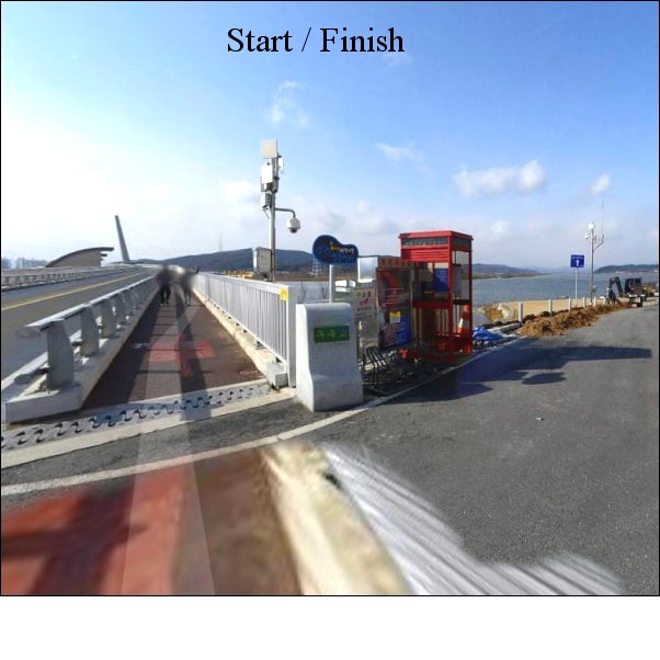
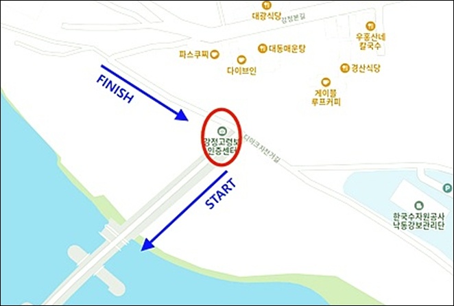
출발지
대구 강정보 / Daegu Gangjeongbo
도로 유형
• 도로 유형
• 도로 노면 상태
도로 유형을 분석하고 있습니다
다운로드
댓글
0
kakao
 세그먼트
세그먼트
웨이포인트
마커 숨김
ESC 키를 누르면 전체화면이 종료됩니다.
카카오맵
지도
위성
세그먼트
3% 이상
500m 이상
-
강정고령보(달성보방향)300m 구간 만든 ('made by 팀 시루자 성괴)'=머저리, 대체 이딴 구간 왜 만든 거야?)0.33km / 4m
-
강정고령보(달성보방향) [Mr.깡]0.81km / 8m
-
강정고령보(달성보방향)300m0.31km / 4m
-
강정고령보(달성보방향)600m 구간 만든 ('made by 팀 시루자 성괴)'=머저리, 대체 이딴 구간 왜 만든 거야?)0.63km / 5m
-
강정고령보(달성보방향)600m0.60km / 5m
-
강정고령보(달성보방향)900m 구간 만든 ('made by 팀 시루자 성괴)'=머저리, 대체 이딴 구간 왜 만든 거야?)0.93km / 5m
-
강정보 스프린트 600m 구간 만든 ('made by 팀 시루자 성괴)'=머저리, 대체 이딴 구간 왜 만든 거야?)0.62km / 4m
-
강정보 스프린트 300m0.30km / 5m
-
강정보 스프린트 600m0.60km / 5m
-
강정고령보2(달성보방향)300m0.30km
-
강정보2 스프린트 300m0.31km
-
성암로 TT _ 동고령 IC 방향 (by FTP)2.00km
-
열뫼삼거리-연리네거리10.37km / 326m
-
열뫼>연리정상 #JYC10.97km / 60m
-
TT 2구간9.91km / 20m
-
목좀축이고가자(오라방)3.39km / 37m
-
야정~우곡중 by akalzh4.49km
-
😨 대봉산고개 북측 #령재치0.76km / 35m
-
대봉산 업0.59km / 26m
-
우곡교~이방 무심사 입구1.67km
-
율평로업힐2.27km
-
🥵 유천령 남측 #령재치2.35km / 123m
-
고령딸기마을로_by daeyong4.28km / 3m
-
분기업힐0.59km
-
중산리깔딱고개(by 한쓰)0.73km / 46m
-
금수면 후평리 산27 2 Climb2.92km / 174m
-
🜲 살티재 남측 #령재치2.47km / 159m
-
tt3.61km / 7m
-
tttt2.44km / 7m
-
부상재 북측 #령재치2.43km / 59m
-
칠곡보 스프린트(시우아빠)0.37km
-
칠곡보-강정보[JS]27.01km / 104m
-
Hill of magic2.63km / 220m
-
황학리정자 - 지천지6.33km / 8m
-
지천 TT1.81km / 8m
-
육신사신길 TT9.14km / 12m
-
신동교차로-하빈면입구5.20km / 2m
-
질질질3.96km / 10m
-
하빈로 끝장 스프린트구간[BY라엘파파]5.51km / 3m
-
하빈삼거리→하빈 파출소1.69km / 17m
-
달서고 업힐1.32km / 16m
-
달서중고 - 문양역 낙타등 TT3.54km / 40m
-
동곡리고개 북측 #령재치0.51km / 25m
-
문양역 사거리 - 강정보4.06km / 13m
-
배수장~강정보1.71km / 12m
웨이포인트