란도너스 퍼머넌트 PT-214 청야수로 GPX 코스파일
설명
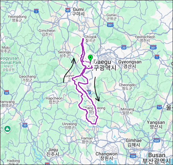 거리: 202 km
상승고도: 600 m
제한시간: 13:28
출발점: 대구
도착점: 대구
코스설계자: 조현호
Last Update : 2024.04.27
https://drive.google.com/drive/folders/1v1oG5GQI5Muh2_lP6ynBQbLGynqq9KcF?usp=drive_link
본 코스는 달성-창녕-합천-고령을 하나의 순환 루프로 연결하여, 옛 가야의 중심이었던 낙동강 유역의 평야 지형과 강변 길이 가진 부드러운 흐름과 고요한 아름다움을 담아내고자 설계되었습니다. 급경사를 비롯한 난이도 높은 구간은 최대한 배제하고, 넓게 열린 들녘과 강바람, 변화하는 하늘빛과 계절의 흐름을 온전히 느낄 수 있도록 지리적, 지형적 특성이 최대한 고려되었습니다.
청(靑) - 하늘과 푸른 평야(들녘)의 색, 넓게 열린 시야와 자유
야(野) - 들판, 바람, 확장되는 공간
수(水) - 낙동강을 중심으로 이어지는 물의 흐름
로(路) - 라이더가 진행하는 길, 여정, 마음의 방향
즉, 청야수로는 "푸른들판 위를 흐르는 물길 같은 여정"을 의미하며, 낙동강 길을 따라 자연의 색감과 평온한 흐름 속에서 스스로를 마주하는 여행. 즉, 라이더 스스로를 발견하고 리듬을 찾아가는 브레베 코스입니다.
This course connects Dalseong, Changnyeong, Hapcheon, and Goryeong into a single circular loop, designed to capture the gentle flow and quiet beauty of the Nakdong River basin — once the heartland of ancient Gaya — with its open plains and riverside paths. Challenging sections with steep gradients have been minimized, while the route maximizes the region’s geographic and topographic character so riders can fully experience the wide-open fields, river breeze, shifting sky colors, and the changing seasons.
Cheong (靑 ) – the color of the sky and the blue plains; openness and freedom
Ya (野 ) – fields, wind, and expansive space
Su (水 ) – the flow of water following the Nakdong River
Ro (路 ) – the rider’s path, journey, and inner direction
In essence, Cheong-Ya-Su-Ro means “a journey like a stream flowing across blue fields.” It is a course that offers a personal, introspective journey—following the trails along the Nakdong River where riders encounter nature’s colors and its serene rhythm, allowing them to discover themselves and find their own cadence.
거리: 202 km
상승고도: 600 m
제한시간: 13:28
출발점: 대구
도착점: 대구
코스설계자: 조현호
Last Update : 2024.04.27
https://drive.google.com/drive/folders/1v1oG5GQI5Muh2_lP6ynBQbLGynqq9KcF?usp=drive_link
본 코스는 달성-창녕-합천-고령을 하나의 순환 루프로 연결하여, 옛 가야의 중심이었던 낙동강 유역의 평야 지형과 강변 길이 가진 부드러운 흐름과 고요한 아름다움을 담아내고자 설계되었습니다. 급경사를 비롯한 난이도 높은 구간은 최대한 배제하고, 넓게 열린 들녘과 강바람, 변화하는 하늘빛과 계절의 흐름을 온전히 느낄 수 있도록 지리적, 지형적 특성이 최대한 고려되었습니다.
청(靑) - 하늘과 푸른 평야(들녘)의 색, 넓게 열린 시야와 자유
야(野) - 들판, 바람, 확장되는 공간
수(水) - 낙동강을 중심으로 이어지는 물의 흐름
로(路) - 라이더가 진행하는 길, 여정, 마음의 방향
즉, 청야수로는 "푸른들판 위를 흐르는 물길 같은 여정"을 의미하며, 낙동강 길을 따라 자연의 색감과 평온한 흐름 속에서 스스로를 마주하는 여행. 즉, 라이더 스스로를 발견하고 리듬을 찾아가는 브레베 코스입니다.
This course connects Dalseong, Changnyeong, Hapcheon, and Goryeong into a single circular loop, designed to capture the gentle flow and quiet beauty of the Nakdong River basin — once the heartland of ancient Gaya — with its open plains and riverside paths. Challenging sections with steep gradients have been minimized, while the route maximizes the region’s geographic and topographic character so riders can fully experience the wide-open fields, river breeze, shifting sky colors, and the changing seasons.
Cheong (靑 ) – the color of the sky and the blue plains; openness and freedom
Ya (野 ) – fields, wind, and expansive space
Su (水 ) – the flow of water following the Nakdong River
Ro (路 ) – the rider’s path, journey, and inner direction
In essence, Cheong-Ya-Su-Ro means “a journey like a stream flowing across blue fields.” It is a course that offers a personal, introspective journey—following the trails along the Nakdong River where riders encounter nature’s colors and its serene rhythm, allowing them to discover themselves and find their own cadence.

출발지
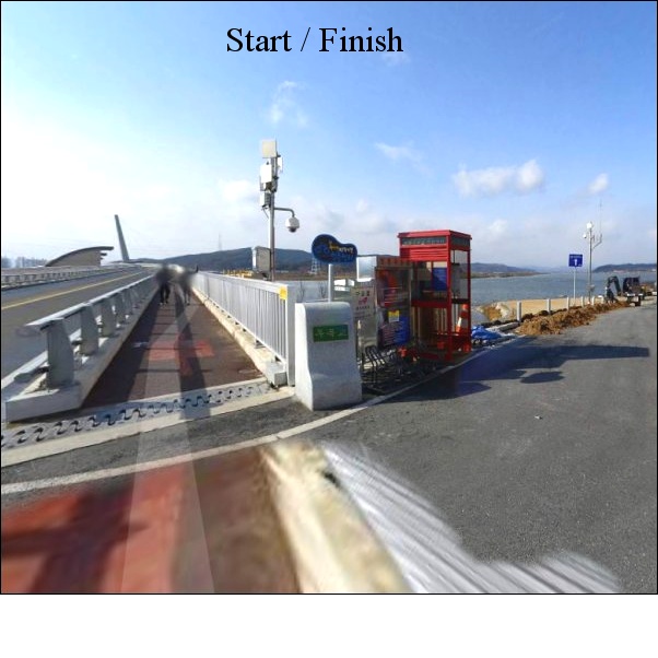
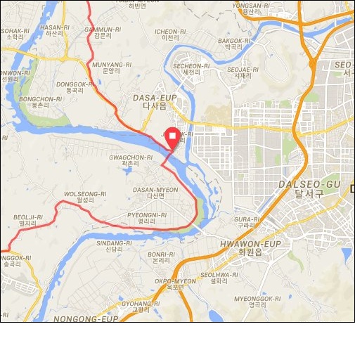
대구 강정보 / Daegu Gangjeongbo
도로 유형
• 도로 유형
• 도로 노면 상태
도로 유형을 분석하고 있습니다
다운로드
댓글
0
kakao
 세그먼트
세그먼트
웨이포인트
마커 숨김
ESC 키를 누르면 전체화면이 종료됩니다.
카카오맵
지도
위성
세그먼트
3% 이상
500m 이상
-
강정고령보(달성보방향)300m 구간 만든 ('made by 팀 시루자 성괴)'=머저리, 대체 이딴 구간 왜 만든 거야?)0.33km / 4m
-
강정고령보(달성보방향) [Mr.깡]0.81km / 8m
-
강정고령보(달성보방향)300m0.31km / 4m
-
강정고령보(달성보방향)600m 구간 만든 ('made by 팀 시루자 성괴)'=머저리, 대체 이딴 구간 왜 만든 거야?)0.63km / 5m
-
강정고령보(달성보방향)600m0.60km / 5m
-
강정고령보(달성보방향)900m 구간 만든 ('made by 팀 시루자 성괴)'=머저리, 대체 이딴 구간 왜 만든 거야?)0.93km / 5m
-
강정보~사문진교TT4.08km / 5m
-
강정고령보 - 달성보, 자전거길 종주 인증센터(made by 팀 시루자 성괴) 구간 만든 ('made by 팀 시루자 성괴)'=머저리, 대체 이딴 구간 왜 만든 거야?)20.94km / 39m
-
N)강정보~달성보20.84km / 89m
-
강정보 스프린트 300m0.30km / 5m
-
강정보 스프린트 600m0.60km / 5m
-
강정고령보2(달성보방향)300m0.30km
-
강정보2 스프린트 300m0.31km
-
사문진교 TT2.07km
-
사문진 TT - JR0.54km
-
사문진교> 화원방향0.84km
-
사문진교→화원교{제 발 좀 천 천 히 가 라}1.08km / 2m
-
화원교(설화리3-9) → 달성보15.48km / 64m
-
화원교(설화리3-9)>>달성보 [TJ]15.44km / 34m
-
신당리자전거길, 돌아가시오1.30km
-
화원교 > 달성보 #JYC14.99km / 62m
-
간경교 - 달성보14.24km / 160m
-
팔각정-달성보12.18km / 136m
-
낙동 river 5km TT section5.25km / 14m
-
테스트1.71km / 3m
-
5km tt JR4.75km / 2m
-
다산다리~위천2.49km
-
4대강 TT평지 역방향 (TJ)3.43km / 19m
-
낙동 river 3.7km TT Reverse Section3.71km
-
이구간 PR이 진정 웃는자의 것이다_by daeyong0.37km / 9m
-
달성보~강변장2.16km / 8m
-
강변장~박석진교1.58km / 2m
-
박석진교-중부내륙낙동대교(by라엘파파)3.12km / 20m
-
오설리 공도 (창녕보방향)[JS]4.07km / 7m
-
구지면 오설리 1.8KM TT (합천창녕보방향~)1.80km
-
구지면 창리 TT (합천창녕보 방향~)0.68km
-
계성~영산(mcc)3.47km / 28m
-
Segment1.60km
-
성사리업힐(mcc)1.13km / 60m
-
정신과시간의방(mcc)3.39km
-
우포1대로 TT4.61km / 8m
-
적포교~이방tt(mcc)9.12km / 54m
-
사또"이방~ 구지 머 이런걸"5.87km
-
이방~우곡교2.11km
-
대봉산 업힐_열뫼방면(by daeyong)1.32km
-
나정리 업힐1.42km / 34m
-
칠곡보 스프린트(시우아빠)0.37km
-
칠곡보->육신사 입구12.11km / 49m
-
칠곡보->적산교차로11.90km
-
칠곡보GS->강나루GS(신)6.93km / 15m
-
칠곡보-강정보[JS]27.01km / 104m
-
낙산교차로 ← 칠곡보9.23km / 76m
-
강정고령보 ◀ 칠곡보26.94km / 198m
-
Chilgok booth down23.37km / 259m
-
칠곡보 > 강정보 #JYC26.40km / 134m
-
new칠곡보->강정보_by jihyang26.06km / 128m
-
왜관->강정보21.64km / 255m
-
TM 19 Waegan Return to the ARC21.32km / 125m
-
칠곡보 3km TT(북→남)2.84km
-
TM 19 25 Mile Turn around to ARC10.61km
-
문산리 업다운1.38km / 17m
-
배수장~강정보1.71km / 12m
웨이포인트