란도너스 퍼머넌트 PT-13 울진 어드벤처 GPX 코스파일
설명
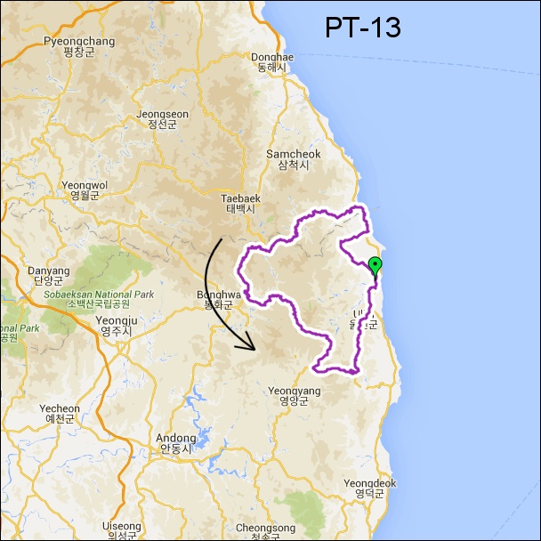 거리: 202km
상승고도: 3,528m
제한시간: 13:28
출발점: 울진
도착점: 울진
코스설계자: Chris Hennessey
Last Update : 2024.
https://drive.google.com/drive/folders/1AYqPEzMuDxn2-GhuMobtFtb96U-SboMH?usp=sharing
이 퍼머넌트는 "어드벤처 시리즈" 중 하나입니다. 어드벤처 퍼머넌트는 험난하고, 오지의 작은 길을 달리며 한국의 가장 아름다운 경치를 보여줍니다. 참가자들은 좋은 컨디션과 완벽한 준비가 필요합니다. 항상 조심해야 합니다. 만약 날씨가 좋지 않다면 진행이 어려울 수 있습니다. 눈이 녹지 않았거나, 비가 오거나, 비가 온 직후에는 위험합니다. 도로 위의 낙석과 모래, 낙엽 등을 조심하세요. 반드시 클릿커버 또는 여분의 신발 등을 준비하세요. 림-브레이크용 카본 휠셋은 사용하지 않는 것이 좋습니다. 어드벤처 시리즈는 24개 이상의 퍼머넌트가 있습니다. 어드벤처 시리즈 중에서 각기 다른 퍼머넌트를 완주하면 세 가지 상을 받을 수 있습니다: 어드벤처-6, 어드벤처-12, 어드벤처-24 어워드. 완주기간 제한은 없습니다. 수상자는 한국 란도너스의 수상 명단에 등록되며, Adv-24 수상자에게는 기념메달이 무료로 발송됩니다. 어드벤처 퍼머넌트는 웹사이트의 "명예 및 수상 - 수상 종목" 에서 확인하세요.
This permanent is one in the "adventure series". Permanents in the adventure series are hard, using small roads in remote countryside and show the most beautiful scenery of the country. Riders must have a good condition and must be well prepared. Take care of safety at all time. If the weather condition is not good, especially after rain or snow, riding can be difficult. Please be careful of small pebbles, sand, and fallen leaves on the road. Be sure to prepare cleat-covers, etc. Carbon wheelsets with rim-breaks are not recommended. There are over 24 different adventure permanents. Three awards can be won for completing different adventure permanents at own choice: Adventure-6 award, Adventure-12 award and the Adventure-24 award. There is no date limit. The winners are listed in the 'Honor Roll' on the Korea Randonneurs website. The winner of the Adv-24 award will receive a medal (no cost).
To see a list of all adventure permanents, please visit the section AWARDS in this website.
거리: 202km
상승고도: 3,528m
제한시간: 13:28
출발점: 울진
도착점: 울진
코스설계자: Chris Hennessey
Last Update : 2024.
https://drive.google.com/drive/folders/1AYqPEzMuDxn2-GhuMobtFtb96U-SboMH?usp=sharing
이 퍼머넌트는 "어드벤처 시리즈" 중 하나입니다. 어드벤처 퍼머넌트는 험난하고, 오지의 작은 길을 달리며 한국의 가장 아름다운 경치를 보여줍니다. 참가자들은 좋은 컨디션과 완벽한 준비가 필요합니다. 항상 조심해야 합니다. 만약 날씨가 좋지 않다면 진행이 어려울 수 있습니다. 눈이 녹지 않았거나, 비가 오거나, 비가 온 직후에는 위험합니다. 도로 위의 낙석과 모래, 낙엽 등을 조심하세요. 반드시 클릿커버 또는 여분의 신발 등을 준비하세요. 림-브레이크용 카본 휠셋은 사용하지 않는 것이 좋습니다. 어드벤처 시리즈는 24개 이상의 퍼머넌트가 있습니다. 어드벤처 시리즈 중에서 각기 다른 퍼머넌트를 완주하면 세 가지 상을 받을 수 있습니다: 어드벤처-6, 어드벤처-12, 어드벤처-24 어워드. 완주기간 제한은 없습니다. 수상자는 한국 란도너스의 수상 명단에 등록되며, Adv-24 수상자에게는 기념메달이 무료로 발송됩니다. 어드벤처 퍼머넌트는 웹사이트의 "명예 및 수상 - 수상 종목" 에서 확인하세요.
This permanent is one in the "adventure series". Permanents in the adventure series are hard, using small roads in remote countryside and show the most beautiful scenery of the country. Riders must have a good condition and must be well prepared. Take care of safety at all time. If the weather condition is not good, especially after rain or snow, riding can be difficult. Please be careful of small pebbles, sand, and fallen leaves on the road. Be sure to prepare cleat-covers, etc. Carbon wheelsets with rim-breaks are not recommended. There are over 24 different adventure permanents. Three awards can be won for completing different adventure permanents at own choice: Adventure-6 award, Adventure-12 award and the Adventure-24 award. There is no date limit. The winners are listed in the 'Honor Roll' on the Korea Randonneurs website. The winner of the Adv-24 award will receive a medal (no cost).
To see a list of all adventure permanents, please visit the section AWARDS in this website.

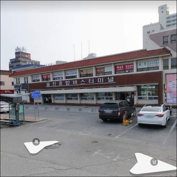
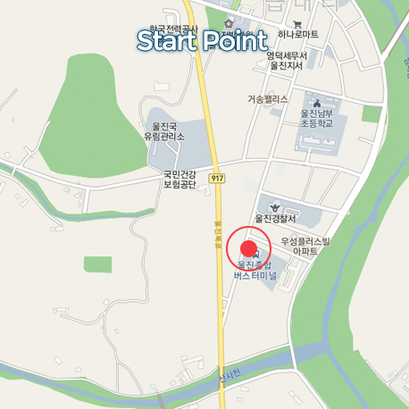
출발지
울진종합버스터미널 Uljin jonghap bus terminal
도로 유형
• 도로 유형
• 도로 노면 상태
도로 유형을 분석하고 있습니다
다운로드
댓글
0
kakao
 세그먼트
세그먼트
웨이포인트
마커 숨김
ESC 키를 누르면 전체화면이 종료됩니다.
카카오맵
지도
위성
세그먼트
3% 이상
500m 이상
-
덕구삼거리-북면. 만든이 윤삥8.37km / 9m
-
월천리 힐클라이밍(나곡리->고포마을)1.23km / 89m
-
고포마을->호산리 TT3.02km / 9m
-
석개재 동측 (고생 끝!)5.11km / 592m
-
석개재6.74km / 701m
-
덕풍계곡-삼방마을 공원 (업힐)2.31km
-
석개재 봉화방면 본격업힐7.25km / 654m
-
가곡면 풍곡리 309 1 Climb1.34km / 186m
-
석포면 석포리 138 66 Climb3.20km / 486m
-
Final 석개재3.12km
-
불미고개 동->서 HS0.53km / 30m
-
청옥산 넛재 북측 #령재치5.30km / 467m
-
청옥산 넛재 남측 다운힐_TheLauf7.13km
-
회고개재 서측 #령재치1.49km / 139m
-
오루숲교차로-영천교삼거리 4km TT #령재치4.24km / 179m
-
광회삼거리-남회룡삼거리 7km TT #령재치7.15km / 292m
-
왜무랑재 북측 #령재치0.63km
-
수하교-수비면 10km TT #령재치9.97km / 293m
-
수비면-구주령 TT #령재치10.43km / 335m
-
구주령 서측 #령재치3.46km / 117m
웨이포인트