란도너스 퍼머넌트 PT-08 새만금 GPX 코스파일
설명
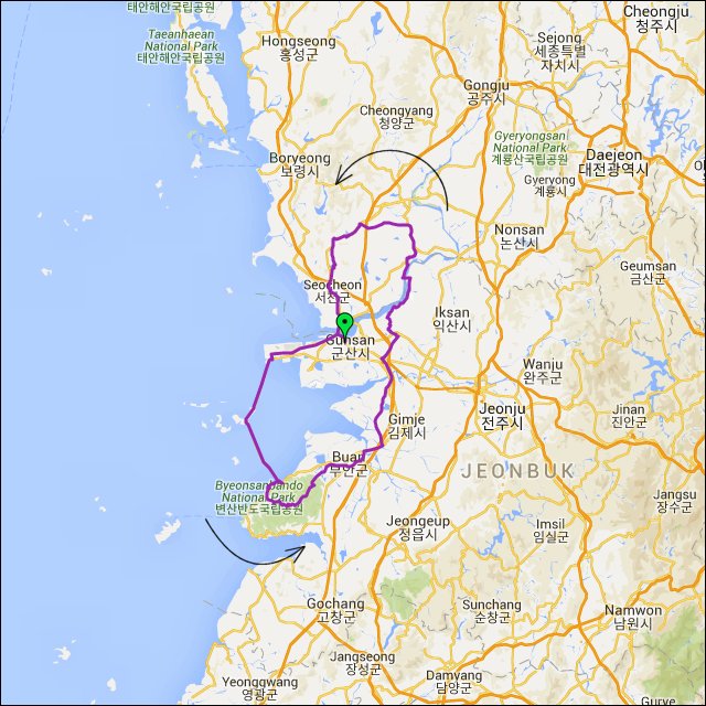 거리: 204km
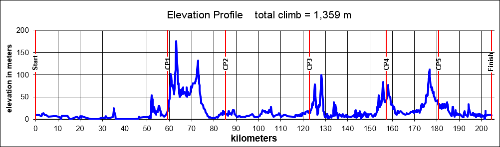
상승고도: 1,301m
제한시간: 13:36
출발점: 군산
도착점: 군산
코스설계자: Bill Goins
Last Update : 2020.
https://drive.google.com/drive/folders/1VfAZnyCoXRaBAdRO1Ng2nfDtNRqjF3QJ?usp=sharing
PT-08 브레베는 군산시 근처의 놀라운 새만금 방파제로 인도합니다. 이 코스는 군산 버스터미널에서 시작됩니다. 남서쪽으로 도시를 빠져나가면 발전하는 산업을 보여주는 조선소가 나오고 곧 새만금 방파제에 도착합니다. 35km의 방파제 라이딩을 즐기고 섬으로 연결되는 큰 댐들을 지납니다. 방파제의 끝에서 오른쪽으로 틀어서 구불구불 해안선을 따라 가다가 왼쪽으로 틀어서 아름다운 변산반도 국립공원으로 들어갑니다. 장관을 이루는 언덕들이 큰 저수지로 인도하고 구불거리는 길을 따라 산을 내려옵니다. 산에서 벗어나면 부안을 통과해서 북쪽으로 향합니다. 좀 더 북쪽으로 가서 군산의 평지를 지나갑니다. 강을 건너고 나서 북쪽으로 향하고 작을 언덕들을 지나고 서쪽으로 틀어서 평야를 건넙니다. 홍산면에 도착하면 남쪽으로 가고 아름다운 호수들을 지나고 강을 한번 더 건너서 도착지인 군산시에 들어옵니다.
This brevet takes riders along the wondrous Saemangeum Seawall near Gunsan City. The course begins at the Gunsan City Bus Terminal. As you exit the city to the southwest past the shipyards and growing industry, you soon find yourself on the Saemangeum Seawall. Enjoy the 35 km trip down the seawall as you link up with islands and cross the large dams. At the end of the seawall you'll make a right turn and travel a few rolling miles down the coastline before turning left and entering the beautiful Byeonsanbando National Park. A spectacular series of climbs takes you up to a large reservoir and then you follow the winding road before descending out of the mountains. Once out of the mountains you head north through Buan and further north through mostly flat terrain north of Gunsan. After you cross the river, you head further north through a series of small climbs before turning west across a flat plain. Once you reach Hongsan-meon you turn south for the push home past a series of beautiful lakes and across the river again as you enter Gunsan City for the finish.
거리: 204km
상승고도: 1,301m
제한시간: 13:36
출발점: 군산
도착점: 군산
코스설계자: Bill Goins
Last Update : 2020.
https://drive.google.com/drive/folders/1VfAZnyCoXRaBAdRO1Ng2nfDtNRqjF3QJ?usp=sharing
PT-08 브레베는 군산시 근처의 놀라운 새만금 방파제로 인도합니다. 이 코스는 군산 버스터미널에서 시작됩니다. 남서쪽으로 도시를 빠져나가면 발전하는 산업을 보여주는 조선소가 나오고 곧 새만금 방파제에 도착합니다. 35km의 방파제 라이딩을 즐기고 섬으로 연결되는 큰 댐들을 지납니다. 방파제의 끝에서 오른쪽으로 틀어서 구불구불 해안선을 따라 가다가 왼쪽으로 틀어서 아름다운 변산반도 국립공원으로 들어갑니다. 장관을 이루는 언덕들이 큰 저수지로 인도하고 구불거리는 길을 따라 산을 내려옵니다. 산에서 벗어나면 부안을 통과해서 북쪽으로 향합니다. 좀 더 북쪽으로 가서 군산의 평지를 지나갑니다. 강을 건너고 나서 북쪽으로 향하고 작을 언덕들을 지나고 서쪽으로 틀어서 평야를 건넙니다. 홍산면에 도착하면 남쪽으로 가고 아름다운 호수들을 지나고 강을 한번 더 건너서 도착지인 군산시에 들어옵니다.
This brevet takes riders along the wondrous Saemangeum Seawall near Gunsan City. The course begins at the Gunsan City Bus Terminal. As you exit the city to the southwest past the shipyards and growing industry, you soon find yourself on the Saemangeum Seawall. Enjoy the 35 km trip down the seawall as you link up with islands and cross the large dams. At the end of the seawall you'll make a right turn and travel a few rolling miles down the coastline before turning left and entering the beautiful Byeonsanbando National Park. A spectacular series of climbs takes you up to a large reservoir and then you follow the winding road before descending out of the mountains. Once out of the mountains you head north through Buan and further north through mostly flat terrain north of Gunsan. After you cross the river, you head further north through a series of small climbs before turning west across a flat plain. Once you reach Hongsan-meon you turn south for the push home past a series of beautiful lakes and across the river again as you enter Gunsan City for the finish.
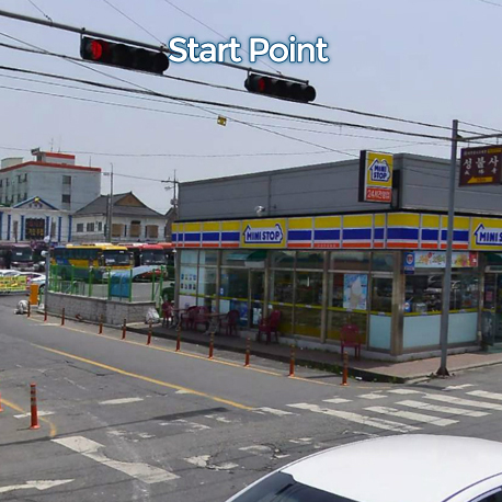
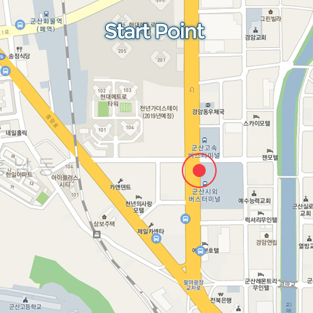
출발지
군산버스터미널 Gunsan Express Bus Terminal
도로 유형
• 도로 유형
• 도로 노면 상태
도로 유형을 분석하고 있습니다
다운로드
댓글
0
kakao
 세그먼트
세그먼트
웨이포인트
마커 숨김
ESC 키를 누르면 전체화면이 종료됩니다.
카카오맵
지도
위성
세그먼트
3% 이상
500m 이상
-
[OOCA] 부안호 내변산 코스9.93km / 151m
-
해학로 북측 8km ITT8.15km / 53m
-
만경대교~대야시장 via 만경로3.42km
-
남서원회관에서 임피 파출소앞까지1.02km / 4m
-
나포 낙타등(웅포방향)1.33km
-
임천 점리 방향0.90km / 35m
-
대백제로 TT, ITT2.52km / 7m
-
덕암리 업힐0.59km / 24m
-
송내-원수 2.7km TT #령재치2.71km / 2m
웨이포인트