란도너스 퍼머넌트 PT-06 인천-대전 GPX 코스파일
설명
 거리: 214km
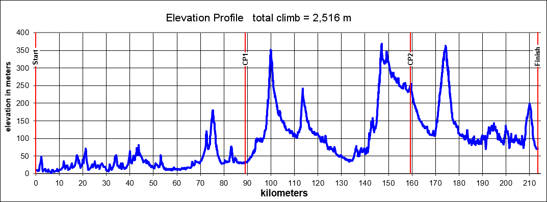
상승고도: 2,516m
제한시간: 14:16
출발점: 인천
도착점: 대전
코스설계자: Jason Ham
Last Update : 2018.
https://drive.google.com/drive/folders/1OvLAXfdXnNQaepjtmJ9h1ZqVlxwrvljs?usp=sharing
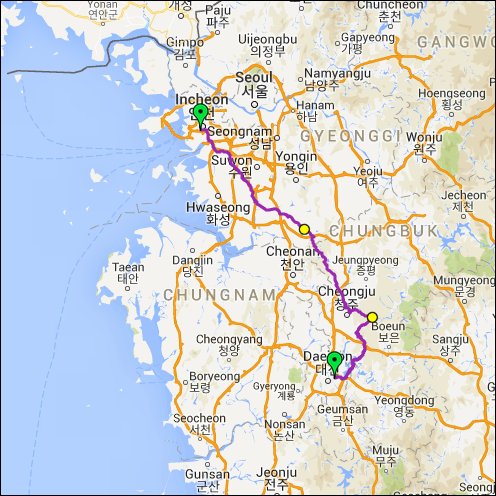
PT-06 퍼머넌트는 인천 종합터미널에서 시작되는 총 214km의 브레베입니다. 남쪽에서 동쪽으로 안산을 지나서 계속해서 남동쪽으로 첫 번째 컨트롤이 있는 안성까지 옵니다. 이 지점까지는 대부분 평지이지만 다음 부분은 언덕들이 있기 때문에 여기서 잠시 쉬어가는 것도 좋습니다. 첫 번째는 경기도에서 충청북도로 들어가는 Rte 313에 있는 아름다운 작은 언덕입니다. 이 지점은 조용하고 즐겁게 타실 수 있고 머지않아 청주를 통과하게 됩니다. 청주 북동쪽을 통과 한 후 동쪽으로 향하고 이 브레베의 하이라이트인 옛 도로 512를 만나게 됩니다. 주의해야 할 점은 이 지점에서 PT-07과는 다르게 터널을 통과하지 않는다는 것입니다. PT-06는 512번 도로를 사용합니다. 이 도로는 차량이 통제 되어있고 등산객들을 위한 도로 부속 시설들이 설치되어있습니다. 도로를 지날 때에는 지방 규칙을 준수하고 등산객들을 배려하면서 지나셔야 합니다. 때로는 자전거에서 내려와서 걸어가야 할 경우가 생길 수도 있습니다. 이 코스는 가파른 스위치백(지그재그식 길)이 2.3km간 이어지고 두 번째 컨트롤인 32번 고속도로 교차로까지 시골길 내리막이 있습니다. 좀 더 남쪽으로 가면 있는 언덕 후엔 대전으로 접근하게 되는데 아름다운 풍경의 호수지역이 나타납니다. 도착지는 대전 버스터미널입니다. 근처에 식사와 돌아가는 교통편을 쉽게 찾을 수 있습니다.
This brevet starts at the Incheon Jonghap bus terminal and is 214 kilometers total. The route takes the rider south through East Ansan and continues southeast to the first control in the city of Anseong. The route is fairly flat up to this point but hills will greet the rider in the next section, so it is not a bad place to rest for a moment and fuel up. The first of these hills is a beautiful little climb on Rte 313 from Gyeonggi Province into North Chungcheong Province. This section is peaceful and enjoyable and brings the rider through the city of Cheongju before long. After passing through the northeast section of the city, the rider heads east for one of the highlights of the ride, old Route 512. It should be noted here that this ride does not pass through the tunnel in this section, unlike its south-north counterpart, PT-07. PT-06 makes use of Rte 512, which has been closed to traffic and had road furniture added to facilitate outdoor activities like hiking. The rider should take care through this section, be respectful of groups of hikers and obey the local laws. That may mean getting off the bike and walking up parts of the climb if the situation dictates it. The route includes a steep section with switchbacks up for 2.3 kilometers and then the rider descends on a regular country road until the Highway 32 Junction which serves as Control 2. After one more notable climb a bit further south, the approach into Daejeon is breathtaking, leading the rider through the lake district with some incredible scenery. The finish is located at Daejeon Express Bus Terminal which should offer the rider several choices for convenient meals and transportation home.
거리: 214km
상승고도: 2,516m
제한시간: 14:16
출발점: 인천
도착점: 대전
코스설계자: Jason Ham
Last Update : 2018.
https://drive.google.com/drive/folders/1OvLAXfdXnNQaepjtmJ9h1ZqVlxwrvljs?usp=sharing
PT-06 퍼머넌트는 인천 종합터미널에서 시작되는 총 214km의 브레베입니다. 남쪽에서 동쪽으로 안산을 지나서 계속해서 남동쪽으로 첫 번째 컨트롤이 있는 안성까지 옵니다. 이 지점까지는 대부분 평지이지만 다음 부분은 언덕들이 있기 때문에 여기서 잠시 쉬어가는 것도 좋습니다. 첫 번째는 경기도에서 충청북도로 들어가는 Rte 313에 있는 아름다운 작은 언덕입니다. 이 지점은 조용하고 즐겁게 타실 수 있고 머지않아 청주를 통과하게 됩니다. 청주 북동쪽을 통과 한 후 동쪽으로 향하고 이 브레베의 하이라이트인 옛 도로 512를 만나게 됩니다. 주의해야 할 점은 이 지점에서 PT-07과는 다르게 터널을 통과하지 않는다는 것입니다. PT-06는 512번 도로를 사용합니다. 이 도로는 차량이 통제 되어있고 등산객들을 위한 도로 부속 시설들이 설치되어있습니다. 도로를 지날 때에는 지방 규칙을 준수하고 등산객들을 배려하면서 지나셔야 합니다. 때로는 자전거에서 내려와서 걸어가야 할 경우가 생길 수도 있습니다. 이 코스는 가파른 스위치백(지그재그식 길)이 2.3km간 이어지고 두 번째 컨트롤인 32번 고속도로 교차로까지 시골길 내리막이 있습니다. 좀 더 남쪽으로 가면 있는 언덕 후엔 대전으로 접근하게 되는데 아름다운 풍경의 호수지역이 나타납니다. 도착지는 대전 버스터미널입니다. 근처에 식사와 돌아가는 교통편을 쉽게 찾을 수 있습니다.
This brevet starts at the Incheon Jonghap bus terminal and is 214 kilometers total. The route takes the rider south through East Ansan and continues southeast to the first control in the city of Anseong. The route is fairly flat up to this point but hills will greet the rider in the next section, so it is not a bad place to rest for a moment and fuel up. The first of these hills is a beautiful little climb on Rte 313 from Gyeonggi Province into North Chungcheong Province. This section is peaceful and enjoyable and brings the rider through the city of Cheongju before long. After passing through the northeast section of the city, the rider heads east for one of the highlights of the ride, old Route 512. It should be noted here that this ride does not pass through the tunnel in this section, unlike its south-north counterpart, PT-07. PT-06 makes use of Rte 512, which has been closed to traffic and had road furniture added to facilitate outdoor activities like hiking. The rider should take care through this section, be respectful of groups of hikers and obey the local laws. That may mean getting off the bike and walking up parts of the climb if the situation dictates it. The route includes a steep section with switchbacks up for 2.3 kilometers and then the rider descends on a regular country road until the Highway 32 Junction which serves as Control 2. After one more notable climb a bit further south, the approach into Daejeon is breathtaking, leading the rider through the lake district with some incredible scenery. The finish is located at Daejeon Express Bus Terminal which should offer the rider several choices for convenient meals and transportation home.
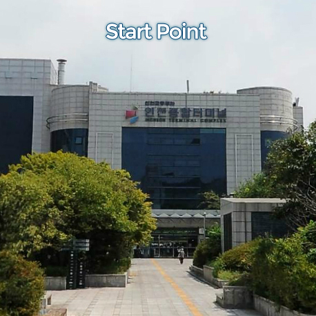
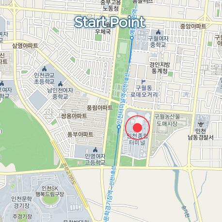
출발지
인천 종합터미널 Incheon Bus Terminal
도로 유형
• 도로 유형
• 도로 노면 상태
도로 유형을 분석하고 있습니다
다운로드
댓글
0
kakao
 세그먼트
세그먼트
웨이포인트
마커 숨김
ESC 키를 누르면 전체화면이 종료됩니다.
카카오맵
지도
위성
세그먼트
3% 이상
500m 이상
-
★선수촌4->담방마을입구41.20km / 15m
-
매소홀터널 서-동1.10km / 16m
-
소래습지공원-월곶중앙로1.52km / 7m
-
달미 출발0.61km / 6m
-
🐫마이쮸 Reverse [2단업힐]1.83km / 59m
-
매송ic를 향해1.41km / 13m
-
송린초등학교업힐(W)1.64km / 30m
-
PEW PEW out from Osan0.43km
-
Out from Osan2.21km / 12m
-
Up again Singlespeed0.86km / 40m
-
[공인]만세고개본격업힐1.80km / 105m
-
원곡면 성은리 산35 3 Climb1.36km / 101m
-
만세고개 북측 #령재치1.20km / 86m
-
캬~~~ 업힐20.41km / 12m
-
OBD_안성_산업단지TT_(모산고가차도 > 제1산업단지 사거리)_ByJYH1.14km / 10m
-
이티재 다운1.25km
-
배티성지TT6.39km / 66m
-
문사고개 북측 #령재치1.12km
-
문백-주유소TT3.31km / 6m
-
문백주유소 스프린트0.87km
-
현암-남성 TT #령재치4.87km / 11m
-
산성로삼거리>낭성면호정교 [by YNK]5.72km
-
추정 ~ 연수원 TT4.95km / 13m
-
R.T.C 평지오픈4.02km / 13m
-
문주삼거리-가덕중-인차리2.94km / 11m
-
계산리마을입구>피반령정상 [by YNK]5.68km / 290m
-
피반령 북측 #령재치4.32km / 250m
-
[공인] 피반령 업힐4.42km / 242m
-
피반령4.02km
-
SMP 삼거리-비석1.55km / 89m
-
피반령 업힐 by 애이든3.93km
-
피반령2Km지점(2/4)2.01km / 113m
-
피반령-회인면-어부동36.57km
-
피반령-회인면 우회-어부동35.93km / 582m
-
피반령 정방향 Last 1Minute Sprint0.52km
-
피반령 다운힐 (역방향)2.86km
-
피반령다운힐-회인방향(초가집가든)2.70km
-
피반령다운7.00km / 3m
-
피반령~어부동31.11km / 271m
-
[TBS] 현대주유소->폐고속도로27.77km / 258m
-
고석리삼거리-회인초입삼거리1.41km / 2m
-
회인면 갈림길 > 남대문교 [by YNK]6.63km / 39m
-
염티재? 어부동?6.75km / 60m
-
어부동25.09km / 245m
-
7 %0.90km / 24m
-
죽암고개 북측 #령재치0.64km / 27m
-
어부동 역방향 FULL20.61km / 232m
-
회남슈퍼1.43km / 52m
-
남대문교에서 주차장17.97km / 201m
-
회남-어부동18.17km / 232m
-
현차 스프린트0.44km / 24m
-
현차 낙타등14.92km / 451m
-
덕고개 북측 #령재치0.60km / 34m
-
회남로 U턴업0.51km / 20m
-
회남로 나선업힐_020.37km
-
방아실삼거리업힐_040.81km
-
수리내미고개 북측 #령재치0.78km / 33m
-
사성동업힐0.49km
-
왜정재 북측 #령재치0.45km / 23m
-
Last 1km1.07km / 5m
-
가양공원업힐11.42km / 78m
-
대전터널 동측 #령재치2.33km / 94m
웨이포인트